
Rising Waters, Rising Risks: East Sepik Faces New Era of Climate-Driven Flooding
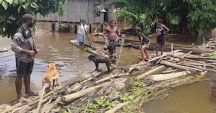
In the heart of East Sepik Province, torrential rains have turned seasonal rivers into destructive forces. Over the past month, more than 12,000 residents across Angoram, Maprik, and Wosera-Gawi districts have been displaced by unusually intense flooding, as the Sepik River burst its banks and inundated homes, gardens, and schools.
While floods are nothing new in the region, the scale and frequency are growing—pushing Papua New Guinea into what local officials are calling a “climate emergency.”
A Village Underwater
In Yamban Village, families are living in overcrowded church halls and school buildings turned into temporary shelters. Crops are rotting under water. Children sleep on woven mats, with limited access to clean water and no functioning toilets.
“We’ve always had wet seasons, but now it’s different,” says Lucy Abawari, a local mother of four. “The water came too fast. We didn’t have time to move everything. And now we don’t know how long we’ll be here.”
Local councillors confirm at least 18 villages are partially submerged, with fears of waterborne diseases and food insecurity looming.
Evacuation Shelters at Capacity
Evacuation centres in Wewak and nearby areas are at full capacity. Aid groups are struggling to distribute essential supplies due to washed-out roads and damaged bridges. Relief is arriving, but slowly.
The National Disaster Centre has sent tarpaulins, rice bags, and water purification tablets, but logistical bottlenecks have hampered wider distribution.
“We need more than short-term relief,” says Provincial Disaster Coordinator John Toka. “This kind of flooding is no longer a one-off—it’s becoming part of our new normal.”
The Climate Link: Rainfall Records Broken
Meteorologists confirm that rainfall levels in East Sepik in April and May 2025 were 40% above historical averages, linked to a warmer-than-usual Pacific Ocean and changing global weather patterns.
Climate scientists warn that intensified La Niña cycles, rising temperatures, and sea-level rise are making extreme weather more common—and more destructive—in PNG.
The PNG Climate Change and Development Authority (CCDA) has urged for stronger disaster risk planning and climate-resilient infrastructure, especially in riverfront communities.
What’s Being Done?
- Provincial governments are now conducting rapid assessments to identify at-risk areas for future relocation efforts.
- NGOs like CARE PNG and Red Cross are deploying mobile medical teams.
- Discussions are underway to introduce flood-resistant housing designs and early warning systems.
But progress remains slow, and funding limited.
Looking Forward: Adapt or Suffer
East Sepik’s crisis is a stark reminder: PNG can no longer treat floods and storms as isolated events. Instead, they are part of a long-term climate challenge—one that will disproportionately impact rural, low-lying communities unless immediate adaptation efforts are made.
From evacuation planning to climate-smart agriculture, the time to act is now.
Conclusion
As muddy waters continue to rise across East Sepik, one thing is clear: this is more than just a seasonal storm. It’s a symptom of a larger, more dangerous shift—and it demands bold, sustained action from leaders, planners, and communities alike.
PNG must prepare—because the next flood won’t wait.